Where Was the Wilderness Wandering?
Quick Summary
The wilderness wanderings of Israel after the Exodus from Egypt lasted forty years and are chronicled primarily in the books of Exodus, Numbers, and Deuteronomy. This period includes major geographic movements and spiritual lessons, from the crossing of the Red Sea to the arrival at the plains of Moab near the Promised Land. The path is difficult to trace with precision, but the key locations reveal a powerful narrative of testing, provision, and covenant identity.
Introduction
The story of Israel’s wilderness wanderings is more than a geographic journey; it’s a theological roadmap of dependence, rebellion, renewal, and trust. While scholars debate the exact path taken, the route we can trace from Scripture includes key waypoints that mark moments of divine intervention, judgment, and mercy. A map of the wilderness wanderings helps us visualize the drama of this pivotal period in Israel’s history.
This article outlines the major locations mentioned in the biblical narrative, offers insights from biblical scholarship, and includes links to related studies on geography and biblical themes. Whether you are studying the journey for academic interest or spiritual insight, understanding the wilderness map helps bring the Exodus narrative to life.
Key Locations of the Wilderness Journey
1. Rameses (Exodus 12:37)
The journey begins in Rameses, located in the Nile Delta region of Egypt. This was one of Pharaoh’s store cities (Exodus 1:11), and likely served as the launch point for Israel’s mass departure. The exact location is debated, but it may correspond to modern Qantir.
2. Succoth (Exodus 12:37–38)
Succoth was the first campsite after leaving Rameses. Some scholars identify it with Tell el-Maskhuta in the Wadi Tumilat, an eastern branch of the Nile.
This map provided by History in the Bible
3. Etham (Exodus 13:20)
Etham lies on the edge of the wilderness. This transitional location marked the exit from settled land into the uninhabited desert. Etham's exact location is unknown, but it is typically placed near the eastern frontier of Egypt.
4. Pi-hahiroth, Migdol, and Baal-zephon (Exodus 14:2)
These are locations near the Red Sea where the Israelites encamped before the miraculous crossing. The Red Sea event (or Sea of Reeds, Hebrew Yam Suph) is one of the most debated geographic moments. Traditional sites include the Gulf of Suez, though others suggest locations nearer to Lake Timsah or the Bitter Lakes.
5. Marah (Exodus 15:23–26)
Marah was known for its bitter waters, which God made drinkable. This miracle emphasized divine provision in the desert. Scholars often locate it near Ain Hawarah in the Sinai.
6. Elim (Exodus 15:27)
Elim was an oasis with twelve springs and seventy palm trees. It provided rest and refreshment, perhaps near modern Wadi Gharandel.
7. Wilderness of Sin (Exodus 16:1)
Not to be confused with the Wilderness of Zin, the Wilderness of Sin lies between Elim and Sinai. Here the Israelites received manna and quail. This area may be near the coast of the southern Sinai Peninsula.
8. Rephidim (Exodus 17:1–7)
At Rephidim, the people quarreled over water, and Moses struck the rock to provide it. This is also the site of the first battle against Amalek. Rephidim is tentatively located in Wadi Feiran.
9. Mount Sinai (Horeb) (Exodus 19–24)
The covenant was given at Mount Sinai, where Moses received the Ten Commandments. The traditional location is Jebel Musa in the southern Sinai Peninsula, but some scholars propose sites in northwest Arabia. See Where Is Mount Sinai?for a full exploration.
10. Taberah, Kibroth-hattaavah, Hazeroth (Numbers 11)
These three locations mark moments of divine judgment and provision. At Kibroth-hattaavah, the people craved meat and suffered a plague. Hazeroth was the next encampment, where Miriam and Aaron challenged Moses’ leadership.
11. Wilderness of Paran (Numbers 12:16–13:3)
From here, spies were sent into Canaan. After the people refused to enter the land, judgment fell and they were condemned to wander.
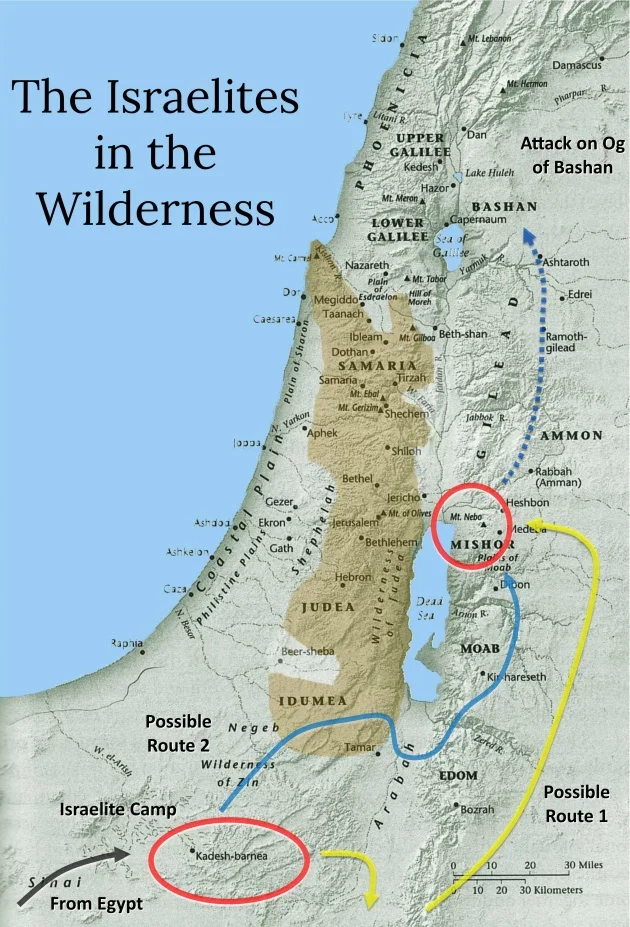
12. Kadesh-Barnea (Numbers 13:26; Deuteronomy 1:19)
Kadesh becomes a major site of encampment and decision. The failed invasion of Canaan and the rebellion of Korah both occur in this vicinity. The exact location is uncertain, but it is often associated with Ain Qudeirat or Ain el-Qudeis in northeastern Sinai.
13. Wilderness of Zin (Numbers 20:1)
In Zin, Miriam dies and Moses strikes the rock at Meribah. It’s part of the greater Negev desert and may overlap with Kadesh.
14. Mount Hor (Numbers 20:22–29)
Aaron dies at Mount Hor. The mountain may be identified with Jebel Harun near Petra in modern Jordan.
15. Oboth, Iye-abarim, Zered, Arnon (Numbers 21)
As the journey turns northeast, these sites track the route along the Transjordan highlands. They are less well-known but indicate Israel’s movement around Edom and Moab.
16. Plains of Moab (Numbers 22–36)
The final encampment before entering Canaan. From here, Moses delivers his final speeches (Deuteronomy) and views the land from Mount Nebo.
Scholarly Resources and Maps
Because the exact locations of many of these places are uncertain, scholars rely on ancient texts, Egyptian records, topography, and archaeological surveys. Excellent resources for deeper study include:
James K. Hoffmeier, Israel in Egypt and Ancient Israel in Sinai
Kenneth A. Kitchen, On the Reliability of the Old Testament
Barry J. Beitzel, The New Moody Atlas of the Bible (especially maps and annotations)
BibleMapper.com and Logos Bible Software for digital map overlays
Bible Odyssey and Biblical Archaeology Society for educational insights
Significance of the Wilderness Journey
The wilderness period is not merely about movement but transformation. Israel moved from being a group of oppressed slaves to a covenant people shaped by law, leadership, and liturgy.
Testing and Trust – God tested Israel’s obedience (Exodus 16:4; Deuteronomy 8:2).
Provision and Presence – Manna, quail, water from the rock, and the cloud/fire pillar mark divine care.
Formation of Identity – The Law, Tabernacle instructions, and priesthood were given here.
Leadership Challenges – Murmuring, rebellion, and the authority of Moses dominate the narrative.
Explore More
For those studying the geography of the Exodus and wilderness period, maps are essential. While no route can be definitively confirmed, comparative models reveal patterns of migration and theological structure. Many maps, such as those by Barry Beitzel or Logos software, overlay modern topography with biblical text to assist students and teachers.
For more study:
Promised Land Map
Where Is Mount Sinai?
Places of the Exodus Journey
FAQ
How long did the wilderness wanderings last?
Forty years, as divine judgment for Israel’s lack of faith in entering Canaan (Numbers 14:33–34).
Where did the Israelites spend most of the 40 years?
Primarily around Kadesh-Barnea in the Wilderness of Zin.
Why is the route so difficult to trace?
Many locations were small, temporary encampments, and modern identification is uncertain.
Is there archaeological evidence for the Exodus route?
Scholars are divided. While large-scale evidence is lacking, some propose indirect clues such as settlement patterns, Egyptian records, or route feasibility studies.