Promised Land Map
Quick Summary
The Promised Land map traces the geographic inheritance promised to Abraham in Genesis 15, described again in Numbers 34, and distributed to the twelve tribes of Israel in the Book of Joshua. Spanning from the “river of Egypt” to the Euphrates in its broadest definition, the Promised Land includes present-day Israel, Palestine, Jordan, parts of Syria, Lebanon, and Egypt. This post includes a map, historical context, biblical references, tribal allotments, and theological significance.
Introduction
Few places in the Bible evoke as much spiritual longing, national identity, and theological symbolism as the Promised Land. From God’s covenant with Abraham to the conquests under Joshua, the promise of land is central to the biblical narrative. But where exactly is the Promised Land? What were its boundaries? How was it divided among the twelve tribes? And how do modern maps and current geopolitics relate to this ancient promise?
This post explores the biblical geography of the Promised Land with historical accuracy, theological reflection, and a detailed map illustrating the division of territory.
Where Is the Promised Land in the Bible?
The phrase "Promised Land" refers to the territory God promised to Abraham and his descendants. This land was often described using landmarks rather than exact borders. In Genesis 15:18–21, the promise is laid out:
“To your descendants I give this land, from the river of Egypt to the great river, the river Euphrates...” (Genesis 15:18, NRSV)
The same promise is echoed in Exodus 23:31 and later detailed in Numbers 34, which outlines the borders of Canaan as the land Israel would soon occupy.
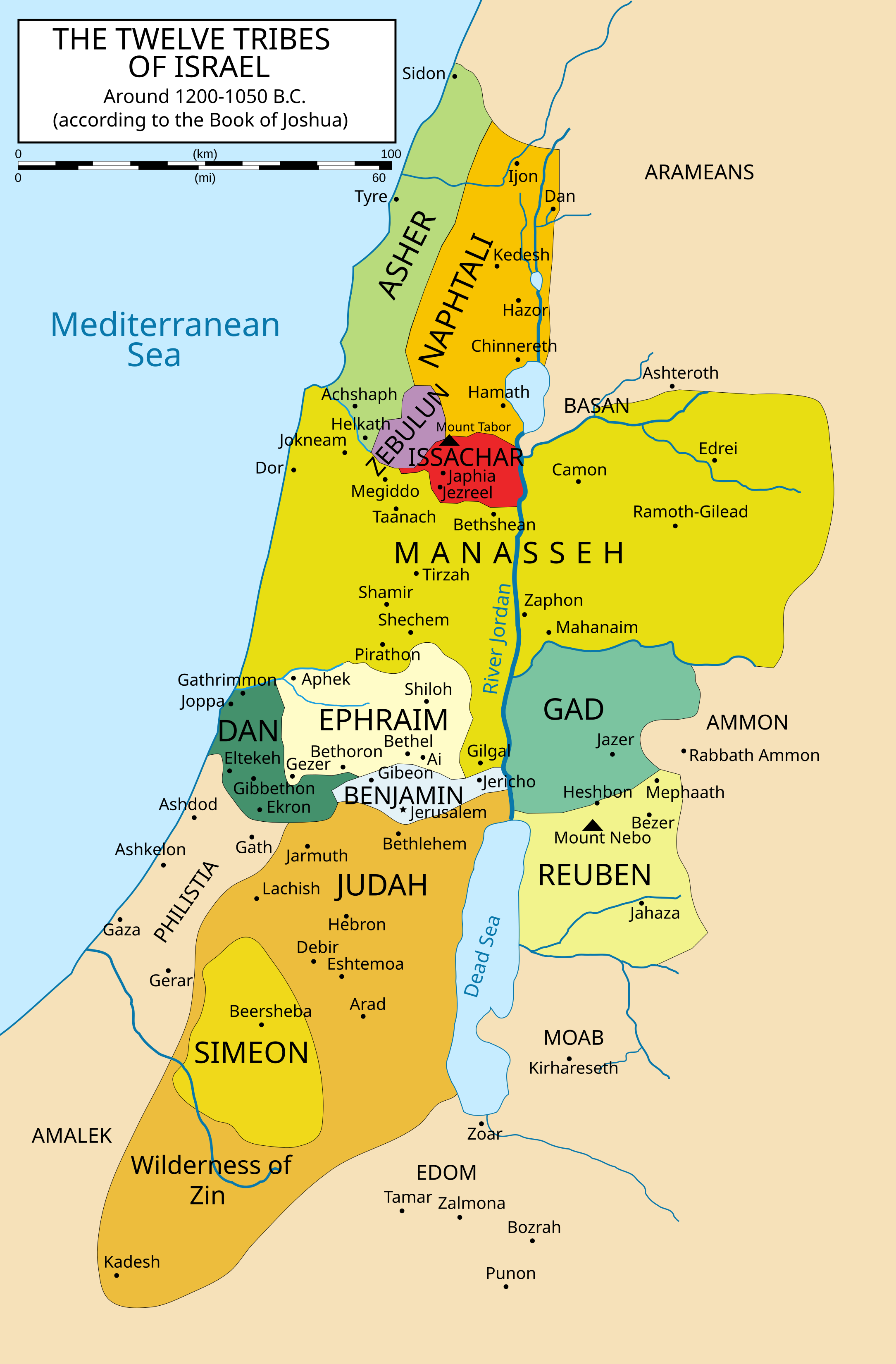
This Wikimedia Commons map shows the approximate division of land among the twelve tribes of Israel as recorded in the Book of Joshua. Boundaries include the territories east and west of the Jordan River, the Mediterranean coast, and key ancient cities.
Biblical Boundaries and Expansions
Genesis 15:18–21: A vast region — from the River of Egypt (likely the Wadi el-Arish, not the Nile) to the Euphrates River — including the land of the Kenites, Hittites, Amorites, Canaanites, Girgashites, and Jebusites.
Exodus 23:31: Reaffirms the boundaries from the Red Sea to the Mediterranean and from the wilderness to the Euphrates.
Numbers 34:1–12: Provides the most detailed delineation of the land assigned to the Israelites upon entering Canaan.
Joshua 13–22: Records how the land was divided among the tribes.
Some scholars (see T.J. Schneider, Ancient Israel: The Old Testament in Its Social Context, p. 87) note that these boundaries often represent theological ideals rather than real historical control.
Joshua 1:4 adds another broad description of the land, reaching “as far as the great river, the river Euphrates,” and including “all the land of the Hittites.” Readers sometimes assume this means the full Hittite Empire at its greatest extent. More likely, the phrase refers to Hittite populations and regions associated with Canaan and Syria, not the entire imperial footprint of Anatolia. In other words, Joshua 1:4 functions like a horizon line. It names the farthest landmarks in view rather than providing a technical border survey.
Division of the Land Among the Twelve Tribes
After entering Canaan, the Israelites divided the land by tribe. The Book of Joshua provides a detailed account:
Reuben, Gad, and half of Manasseh received land east of the Jordan (Transjordan).
The other tribes were allotted portions west of the Jordan:
Judah received the southern region.
Ephraim and the other half of Manasseh occupied the central hill country.
Benjamin had a narrow strip between Judah and Ephraim.
Simeon was allotted land within Judah's territory.
Zebulun, Issachar, Asher, and Naphtali occupied the northern areas.
Dan initially settled in the west but later migrated northward (see Judges 18).
The Levites received no land inheritance, only cities scattered throughout the tribal regions (see Joshua 21).
Boundaries from Numbers 34
Here’s how Numbers 34:1–12 outlines the land's boundaries:
Southern Border: From the Wilderness of Zin along Edom to the Salt Sea.
Western Border: The Great Sea (Mediterranean).
Northern Border: From the Great Sea to Mount Hor, then to Zedad.
Eastern Border: From Hazar-enan to Shepham and down to the Jordan.
These were the boundaries of Canaan, not the broader Abrahamic boundary extending to the Euphrates.
Greater vs. Lesser Promised Land
Scholars and theologians distinguish between the Greater Promised Land (Genesis 15:18) and the Immediate Promised Land of Canaan (Numbers 34):
Greater Israel includes regions never fully under Israelite control.
Lesser Canaan corresponds with the land occupied after Joshua’s conquest.
The phrase “From the river of Egypt to the Euphrates” became a symbolic phrase for God’s expansive faithfulness, even if the full area was never realized politically. Some interpreters place Joshua 1:4 in this same “greater promise” category, reading its landmark language as an idealized statement of the land’s full scope rather than a claim that Israel possessed the entire Hittite imperial range.
The Promised Land and Modern Geography
Today, the ancient Promised Land spans:
Israel and the Palestinian territories
Parts of Jordan and Lebanon
Sections of Syria
The northeastern edge of Egypt
Modern political borders do not reflect tribal boundaries, but many biblical sites can still be visited today. For example:
Hebron (Judah’s territory) is in the West Bank
Shiloh (where the Tabernacle was located) lies in the central hills
Dan is in modern northern Israel near the Lebanese border
Symbolic Meaning of the Promised Land
While the land was a physical inheritance, the Promised Land became a symbol of rest, hope, and divine fulfillment. In the New Testament, Hebrews 11:9–10 and Revelation 21 transform the concept into a heavenly city — “a better country.”
The Promised Land in Worship and Hymns
Christian hymns often invoke “Canaan” or “the Promised Land” as symbols of Heaven:
“I am bound for the Promised Land…”
“On Jordan’s stormy banks I stand…”
These allusions connect the historical land to the spiritual journey of faith, longing, and ultimate rest in God.
Scholarly Resources and Citations
To explore the Promised Land in greater detail, consider these references:
T.J. Schneider, Ancient Israel: The Old Testament in Its Social Context, Fortress Press.
John Bright, A History of Israel, Westminster John Knox Press.
Yohanan Aharoni, The Land of the Bible: A Historical Geography, Westminster Press.
Carta Jerusalem Atlas, 5th Edition.
These works provide critical insight into ancient borders, archaeological support, and theological significance.
Promised Land Boundaries and Today’s Debates
The term “Promised Land” is sometimes invoked in political or theological arguments about modern Israel’s borders. However, biblical promises were covenantal and theological, not just territorial. The land was tied to faithfulness, obedience, and covenantal life — not conquest alone.
Conclusion
The Promised Land map is more than a cartographic tool. It is a visual representation of God’s promises, Israel’s history, and the theological longing for peace and belonging. From Genesis to Revelation, the land stands as a thread linking covenant, community, and hope.
Whether read historically, theologically, or symbolically, the Promised Land reminds readers that God’s promises are wide-reaching — from Abraham’s journey to the New Jerusalem.
See Also
Reader Question: Does “all the land of the Hittites” mean the entire Hittite Empire?
Not necessarily. The phrase is often read as referring to Hittite regions and peoples in and around Canaan and Syria, or as a conventional way of describing the northern reach of the land promise (Joshua 1:4), rather than the empire’s maximum historical borders.